Document
Investigation report into flooding incident of 16th February 2020 Varteg Road, Ystalyfera
Introduction
An investigation has been undertaken by Neath Port Talbot Council as Lead Local Flood Authority in response to the flooding that occurred at Varteg Road, Ystalyfera on 16th February 2020. This report is a summary of the investigation and includes relevant information required to meet the statutory requirements placed on the Authority by Section 19 of The Flood and Water Management Act 2010. Information regarding the duties and responsibilities placed on a Lead Local Flood Authority (LLFA) to investigate flooding can be found in Appendix A.
One of the requirements of Section 19 is that an investigation report must identify which Risk Management Authorities (RMA) have relevant flood risk management functions. Appendix B provides a summary of the roles and responsibilities of the RMA’s within Neath Port Talbot.
Through the investigation process, it was determined that the relevant RMA’s for the flooding that occurred at Varteg Road are:
- NPTCBC as Lead Local Flood Authority
- NPTCBC as Highway Authority
- Dwr Cymru Welsh Water as the water company
In addition, it was found that a number of land owners/developers and those with riparian responsibilities for watercourses are also relevant in this instance.
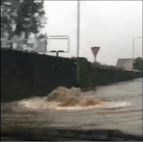
The flooding at Varteg Road, Ystalyfera occurred at approximately 00:30hrs on Sunday 16th February 2020 following a period of prolonged and intense rainfall that started on Saturday 15th February at approximately 03:00 hrs and ended Sunday 16th February at 07:00 hrs.
Emergency response actions were undertaken by NPTCBC to help reduce the flood risk. NPTCBC are in the process of implementing a number of flood mitigation methods in order to protect residents from future flooding. All risk management authorities are aware of the recommendations from the previous report and made aware of any recommendations highlighted in this report.
2016 event summary
In 2016, an investigation was undertaken by NPTCBC in response to the flood event that occurred on 3rd September 2016 at Varteg Road, Ystalyfera. Following a prolonged intense rainfall event eighteen properties along Varteg Road and one outbuilding on Ynysydarren Road suffered internal flooding.
It is encouraged the 2016 report is read in conjunction with the findings details in the following.
In 2016 NPTCBC concluded a key drainage system shown in figure 12 Connection A to B was severed during the construction of the nearby Asda Stores site, being one of the key contributing factors for the property flooding along Varteg Road. Water intended to convey through the culvert was being discharged into the ground at the location of the Asda site, by way of percolation and dispersal. As such, the existing drainage network was simply acting as an attenuation tank.
Investigations also identified a partial collapse on another culvert within privately owned land off Ynysydarren Road that had a significant effect on the flood extent. The water that surcharged from an adjacent inspection chamber within the highway flowed through the Varteg Estate to the low point at the Ynysydarren and Varteg Road junction.
A mitigation measure was introduced by the NPTCBC that involved the construction of a temporary pumping station on the line of the blocked Asda culvert. The system currently pumps surface water overland into the A4067 highway drainage system, and consequently its effectiveness at dealing with intense rainfall is limited.
| No | Action By | Action | Action to date |
|---|---|---|---|
| 1 | Asda Land Owner/ Developer | Resolve the Issue with the lost drainage | Investigations remain. The Authority is developing a business case alongside correspondence with stakeholders in order to find an appropriate solution. |
| 2 | Property Owners | Consider flood risk to own properties | The Authority has implemented property resilience measures to properties at Varteg Road |
| 3 | DCWW - Dwr Cymru Welsh Water | Ensure efficient operation of public combined and surface water sewers | No issues detected upon investigation with integrity of sewer network. Surcharge water from ynysydarren culvert entered the network causing surcharge to sewer system |
| 4 | Land Owners | Remove any obstructions within a watercourse if found | As a LLFA the Authority has utilised its land drainage powers to enforce removal of impediments within private land. |
Flood incident
Location of flooding
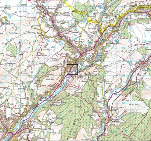
Varteg Road is located in the south of the electoral ward of Ystalyfera which is situated in the upper Swansea valley. The upper Swansea valley is located in the north of Neath Port Talbot County Borough.
Rainfall event and analysis
Between 03:00 hrs Saturday 15th February and 07:00 hrs Sunday 16th February continuous rainfall fell across the county borough which lasted approximately 27 hours, peaking in intensity early Sunday morning around 02:00 hrs. Varteg Road sits in the river Tawe catchment that along with the river Neath catchment, received the highest levels of rainfall over the 2 days.
The river Tawe catchment is approximately 26,877ha in size and encompasses sections of the Brecon Beacons that drain via a number of recognised watercourses on its southern slopes before converging on the river Tawe near Glyntawe. Figure 2 below shows the catchment size with the location of Varteg Road labelled.

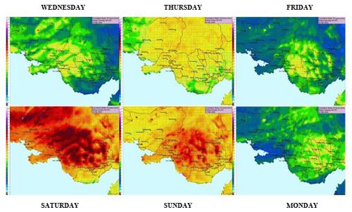
The average levels of rainfall that fell in the borough across a 6-day period are displayed in Figure 3. It shows how consistent rainfall fell for 3 days leading up to the weekend before increasing in intensity for 2 days. It illustrates how high the average rainfall levels were across Saturday and Sunday. Over the 2 days of the storm it has been calculated that an average of 61.3mm of rainfall landed within the county boundary over a 48 hour period.
A summary of the rainfall analysis in NPTCBC:
- Recorded data from Saturday 15th revealed the rainfall ranged from 113mm to 40mm in the 24hr period across the catchment, averaging out to 76.5mm.
- Recorded data from Sunday 16th revealed the rainfall ranged from 63mm to 29mm in the 24hr period across the catchment, averaging out to 46mm.
Figure 4 illustrates the magnitude of the rainfall that fell on the Ystalyfera area. The rainfall hydrograph data from Glan-Rhyd sewage treatment plant is 1km north east of Varteg Road and demonstrates how rainfall steadily increased in intensity from Friday afternoon through to the flood event on Sunday 00:30 hrs.
A summary of the rainfall analysis at Ystalyfera shows:
- Friday – 15:00 hrs, rainfall fell at a maximum 3.4mm/hr.
- Saturday Morning – 11:00 hrs, rainfall increased to 5.4mm/hr.
- Saturday Evening – 23:00 hrs, rainfall increased further to 8.4mm/hr.
- Sunday Morning – 02:00 hrs, rainfall peaked at 12.2mm/hr.
Across Saturday and Sunday the authority responded to many flood related calls across the borough which the emergency ‘out of hours’ staff responded to. However, at approximately 00:30 hrs Sunday 16th February the first floodwaters entered properties on Varteg Road.
It is important to note that the floodwater continued to rise throughout a period of approximately four hours with the first property reporting flooding at 00:30 hrs and the last at 04:00 hrs. It is also understood the floodwaters did not recede until around midday Sunday, the following day.

Flood extent
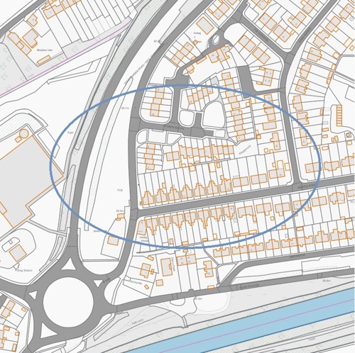
A total number of 29 properties suffered internal flooding on 16th February in Ystalyfera, including 27 on Varteg Road, 1 on Ffordd Emlyn and 1 outbuilding on Ynysydarren Road.
Figure 5 below illustrates those properties.
Site characteristics
The residential area of Varteg Estate and the immediate surrounding area forms part of the river Tawe flood plain in Ystalyfera. The Varteg catchment measures approximately 400m at its widest point and covers an area of circa 10 hectares.
The topography of the area is relatively flat, varying in level between 62.9m and 56.6m above ordnance datum the latter being at its lowest point that is situated around the Varteg Road and Ynysydarren junction. The river Tawe borders the site to the South East with a steep sided hillside and A4067 embankment to the North West. The underlying superficial geology consists of alluvial silts, sands and clays deposited over time by the river Tawe however, little of these soils are exposed due to the hardstanding development that is Varteg Estate.
Drainage networks and flood paths
Figure 6 identifies surface water, land drainage and DCWW networks in the vicinity of the flooding incident, as identified in the legend.

There is also a widespread DCWW combined sewer network which is fed into a trunk sewer that bisects the catchment, running through the Varteg Estate and Ynysydarren Road junction before continuing down the Swansea valley, shown in Figure 7.

Varteg Estate
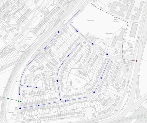
Figure 8 below illustrates the surface water flow paths in the area discharging into the 1.2m diameter culvert (MH1 shown in Figure 10), which runs in a Westerly direction under the A4067.
Ynysydarren
A culverted watercourse crosses under Ynysydarren Road near to the northern most corner of Ystalyfera rugby fields. The culvert runs under what was private land (which has since been purchased by the council), along the northern boundary of the fields before entering a chamber in the grounds of numbers 1 – 35 Maes Y Darren, which is managed by Tai Tarian. From this point the culvert turns 90o before discharging into the Afon Twrch. The culverted watercourse does not interact with the drainage system serving the Varteg Estate during normal flows. However if the culvert surcharges from the Ynysydarren Road inspection chamber (shown in figure 11), as it did during the 2016 and 2020 flood event the water is channelled through the Varteg Estate to the low point (MH1 – Figure 10) of the catchment via the flow path seen below in Figure 9.

Summary of water flows on 16th February
During the flood event, surcharged water from the contributing sources and surface water run off all flowed to the low point in the area at the Ynysydarren and Varteg Road junction.
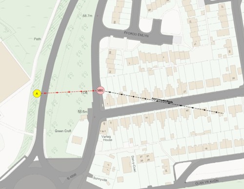
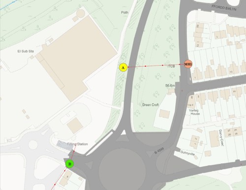
Chamber MH1 (figure 10) is situated at the lowest point and is the point at which all surface water drainage networks discharge to. MH1 is built on a 1.2 metre diameter culvert that flows downstream east to west under the Varteg Estate, that would have originally supplied water to the old iron/tin works now conveys water from the estate under the A4067 towards the recently developed ASDA site. The section under the Varteg Estate itself is believed to be redundant other than it provides some storage capacity for flows entering MH1. Further to the investigation it is believed that water was then historically conveyed via a culvert system down the valley, before out falling downstream on the banks of the river Tawe.
Detailed investigation findings
Ynysydarren
Previously it was investigated that the section of the culvert downstream of Ynysydarren Road highlighted reduced capacity, caused by a partial collapse of the culvert on privately owned land.
Since these inspections, the Council acting as LLFA, decided to purchase the 3rd party land in order to undertake vital repair works to the culvert in order to prevent flooding to the community.
The existing culvert has since been removed and replaced with a new larger 900mm diameter pipe. This scheme has already proved successful and reduced the flood risk to the residents of the Varteg Estate.
Varteg Estate
During the latter hours of Saturday the 15th February, the design capacity of the surface water drainage system in Varteg Estate was exceeded, causing overland flows to the junction of Ynysydarren and Varteg Road. As previously stated, it was the additional surcharging flows from the Ynysydarren chamber that had a significant impact on the drainage capacity. At approximately 00:30hrs Sunday 16th February along Varteg Road started to flood.
Under the WG small scale-funding scheme, NPTCBC commissioned an independent subcontractor to install flood defence doors to 12no properties residing in Varteg Road. Officers in immediate attendance following the flood event recorded ingress of water through the doors was present.
Inspections were also made to the temporary pumping station near to MH1, which were deemed to be working at the time of the event. It was the additional surcharged water from Ynysydarren, alongside consistent volume of water that fell during a short period of time that exceeded the capabilities of the temporary pumping station.
DCWW Network
During the early hours of Sunday 16th February, the DCWW sewer network surcharged resulting in combined sewerage flowing through Varteg Estate and contributing to the flooding. (See figures 7 & 9).
After investigations it was found the additional flows of surface water from the Ynysydarren culvert that entered the sewerage network were the cause of surcharging sewer network. During DCWW investigations, no issues to the structural integrity of the sewer network were identified.
Carrier drain from Chamber MH1 to Point A (refer figure 10)
The authority has appointed a consultant to produce an outline business case (OBC) and outline detailed design to re-establish the connection between point A and B. Since the 2020 event the council have completed the OBC and are due to complete the detailed design in April 2021. The proposed scheme is intended to once again allow surface water to flow unaided away from the Varteg housing estate and minimise the current flood risk to the local community. The report and design has been commissioned through the Welsh Governments Flood and Coastal Erosion Risk Management Programme and it’s the Authority’s intention to further the project to construction phase during financial year 21-22.
Summary of investigation findings
As per previous, it is the conclusion of the Authority’s investigations that the drainage system, which believed to have previously connected point A and point B (Figure 12), has been removed. This along with the impediments and collapses to the culvert on private land adjacent to Ynysydarren Road, to be the fundamental reason for the flooding.
Believing the connection from point A and point B to have been severed, the Authority has commissioned a business case with detailed designs to establish the connection. It is the Authority’s intentions to progress the project during financial year 2021-22.
As a LLFA the council initiated proceedings to purchase land adjacent to Ynysydarren road in 2020 utilising its land drainage powers, and have since rectified the length of neglected culvert.
The temporary mitigation measures introduced by the Council since the flood included building a new chamber near to the low point of the estate and installing a pump system. The system however only pumps surface water overland into the A4067 highway drainage system, and consequently its effectiveness at dealing with flood conditions can only be considered to be limited. To reduce the significant resource issues associated with maintaining the operation of the pumps the authority has since completed the installation of a permanent power supply to replace the existing fuel powered generator.
It is noted there have been some previous reports of more limited flooding by residents at Varteg Road since the development of the ASDA site; however none met the criteria for a Flood Investigation to be undertaken.
Recommended action
The actions contained within Table 2 are recommended to be taken forward by the relevant RMA or property/landowner.
| No | Action By | Action | How will it be achieved? |
|---|---|---|---|
| 1 | NPTCBC & Asda Land Owner/ Developer | Resolve the Issue with the lost drainage connection |
Consider the findings of the investigation in relation to the lost drainage connection and continue forward progress to re-establish connection. Update 17/5/21: Investigation Complete |
| 2 | NPTCBC | Consider flood risk to own properties |
To undertake a flood alleviation scheme in partnership with Welsh Government to re-construct culvert connection between Varteg Road and Glan Yr Afon culvert.
Update 6/12/21: Completion Date 26th January 2022 |
| 3 | NPTC & DCWW | Ensure efficient operation of public combined and surface water sewers | To commission an investigation into current property flood protection measures |
Appendices
Appendix A
The Flood Risk Regulations 2009 and the Flood and Water Management Act 2010 identify NPTCBC as the Lead Local Flood Authority (LLFA) for the area. This has placed a number of flood risk management duties and responsibilities on the Council. In particular, Section 19 of the Flood and Water Management Act 2010 places a duty upon NPTCBC to undertake investigations into flood events to the extent that it considers necessary.
A ‘Risk Management Authority’ (RMA) means:
Flood and Water Management Act: Section 19 - Local authorities: investigations
- On becoming aware of a flood in its area, a lead local flood authority must, to the extent that it considers it necessary or appropriate, investigate—
- which risk management authorities have relevant flood risk management functions, and
- whether each of those risk management authorities has exercised, or is proposing to exercise, those functions in response to the flood.
- Where an authority carries out an investigation under subsection (1) it must—
- publish the results of its investigation, and
- notify any relevant risk management authorities.
Flood and Water Management Act (2010), S.19, c.29, London: HMSO
- Natural Resources Wales (NRW)
- a lead local flood authority,
- a district council for an area for which there is no unitary authority,
- an internal drainage board,
- a water company, and
- a highway authority.
When considering if it is necessary or appropriate to investigate a flood event within its area, NPTCBC will review the severity of the incident along with the number of properties affected and the frequency of such an occurrence. The Council’s Local Flood Risk Management Strategy sets out the criteria to be used when considering a Flood Investigation Report.
Appendix B
RMAs in Neath Port Talbot have responsibilities in relation to flood risk management. Table 2 below identifies numerous sources of flooding and the RMA that has responsibility and flood risk management functions relating to a particular source of flooding.
| Flood Source | Natural Resources Wales | Lead Local Flood Authority | Water Company | Highway Authority |
|---|---|---|---|---|
| Main River | * | |||
| Ordinary Watercourse | * | |||
| Surface Water | * | |||
| Surface Water originating on the Highway | * | |||
| Sewer Flooding | * | |||
| The Sea | * | |||
| Ground Water | * |
The general responsibilities placed upon RMAs in relation to flood risk management are outlined below.
Natural Resources Wales
Natural Resources Wales (NRW) is responsible for managing the risk of flooding from main rivers and the sea. NPTCBC works closely with NRW, especially when managing flood risk from combined sources and in the event of a large flood incident. NRW also provide a flood warning service throughout Wales in areas at risk of flooding from rivers or the sea.
Neath Port Talbot County Borough Council as LLFA
NPTCBC is responsible for managing the flood risk related to ordinary watercourses, groundwater and surface water. NPTCBC has produced a Flood Risk Management Plan in line with the Flood Risk Regulations 2009 which sets out how the Authority proposes to undertake this function. In addition to this and as previously stated, the Authority also has a Local Flood Risk Management Strategy which was produced to meet the requirements of the Flood and Water Management Act 2010. There are a number of duties and responsibilities placed upon the Authority as the LLFA for the area by these two legislative documents. The Authority is also responsible for consenting works on ordinary watercourses and enforcing the removal of any unlawful structure or obstruction within the watercourse.
Neath Port Talbot County Borough Council as Highway Authority
The Authority undertakes routine maintenance on the water conveyance infrastructure contained within the highway including culvert and gully cleansing operations. These operations, together with visual inspections of the condition of such assets are undertaken to reduce the risk of flooding on the adopted highway network and adjacent land.
Dwr Cymru Welsh Water
Dwr Cymru Welsh Water (DCWW) is responsible for the supply of drinking water and for taking away, treating and properly disposing the wastewater that is produced throughout Wales. Any flooding that occurs from the overload of public sewers or burst water mains is the responsibility of DCWW.
South Wales Trunk Road Agency
The South Wales Trunk Roads Agency (SWTRA) is responsible for maintaining and managing the trunk road network throughout South Wales, including any associated drainage and flood risk assets.
Land/property owners
Under common law, land or property owners have rights and responsibilities relating to any watercourse that passes through or adjacent to the boundaries of their land. This means that the landowner must:
- Pass on flow without obstruction, pollution or diversion affecting the rights of others.
- Accept natural flood flows through their land, even if caused by inadequate capacity downstream, as there is no common law duty to improve a watercourse.
- Maintain the bed and banks of the watercourse (including trees and shrubs growing on the banks) and clear any debris, natural or otherwise, including litter and animal carcasses, even if it did not originate from their land.
- Not cause any obstructions to the free passage of fish.
- Keep the bed and banks clear from any matter that could cause an obstruction either on their land, or by being washed away by high flow to obstruct a structure downstream.
- Take responsibility for protecting their property from seepage through natural or constructed banks.
- Keep clear any structure that they own such as culverts, trash screens, weirs etc.
Under the FWMA 2010, a landowner needs consent from the Council if they want to construct a culvert or flood relief control structure on any ordinary watercourse.