Flood Incident
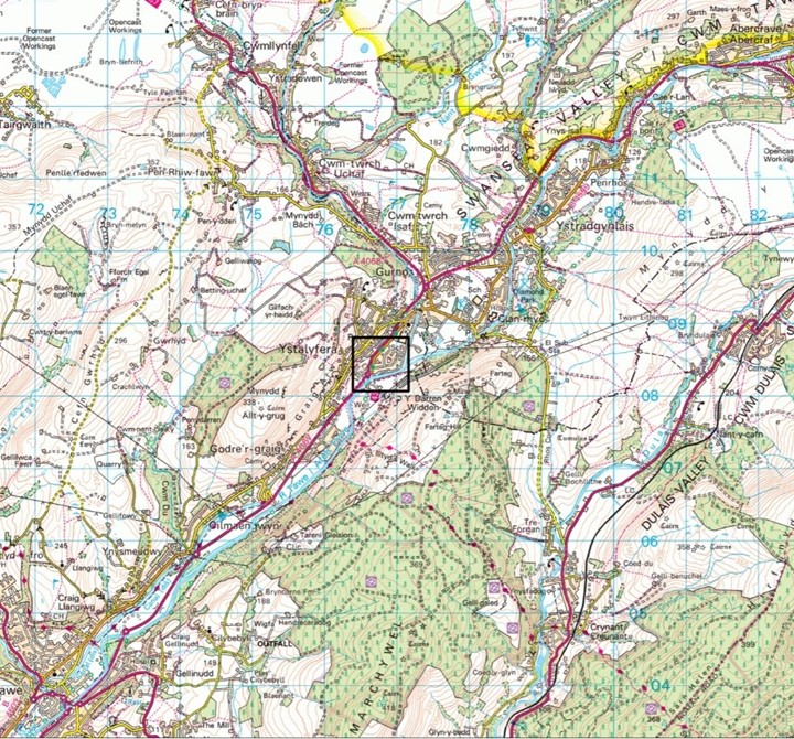
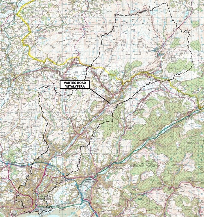
Varteg Road is located in the south of the electoral ward of Ystalyfera which is situated in the upper Swansea valley. The upper Swansea valley is located in the north of Neath Port Talbot County Borough.
Between 03:00 hrs Saturday 15th February and 07:00 hrs Sunday 16th February continuous rainfall fell across the county borough which lasted approximately 27 hours, peaking in intensity early Sunday morning around 02:00 hrs. Varteg Road sits in the river Tawe catchment that along with the river Neath catchment, received the highest levels of rainfall over the 2 days.
The river Tawe catchment is approximately 26,877ha in size and encompasses sections of the Brecon Beacons that drain via a number of recognised watercourses on its southern slopes before converging on the river Tawe near Glyntawe. Figure 2 below shows the catchment size with the location of Varteg Road labelled.
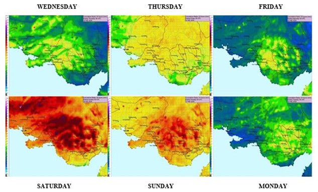
The average levels of rainfall that fell in the borough across a 6-day period are displayed in Figure 3. It shows how consistent rainfall fell for 3 days leading up to the weekend before increasing in intensity for 2 days. It illustrates how high the average rainfall levels were across Saturday and Sunday. Over the 2 days of the storm it has been calculated that an average of 61.3mm of rainfall landed within the county boundary over a 48 hour period.
A summary of the rainfall analysis in NPTCBC:
- Recorded data from Saturday 15th revealed the rainfall ranged from 113mm to 40mm in the 24hr period across the catchment, averaging out to 76.5mm.
- Recorded data from Sunday 16th revealed the rainfall ranged from 63mm to 29mm in the 24hr period across the catchment, averaging out to 46mm.
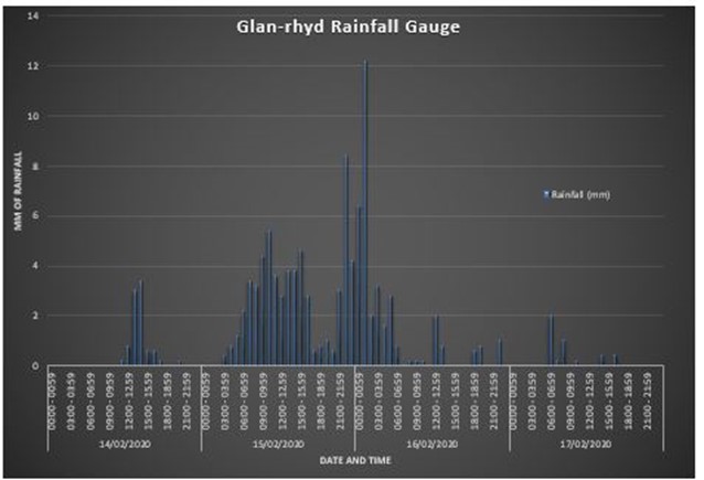
Figure 4 illustrates the magnitude of the rainfall that fell on the Ystalyfera area. The rainfall hydrograph data from Glan-Rhyd sewage treatment plant is 1km north east of Varteg Road and demonstrates how rainfall steadily increased in intensity from Friday afternoon through to the flood event on Sunday 00:30 hrs.
A summary of the rainfall analysis at Ystalyfera shows:
- Friday – 15:00 hrs, rainfall fell at a maximum 3.4mm/hr.
- Saturday Morning – 11:00 hrs, rainfall increased to 5.4mm/hr.
- Saturday Evening – 23:00 hrs, rainfall increased further to 8.4mm/hr.
- Sunday Morning – 02:00 hrs, rainfall peaked at 12.2mm/hr.
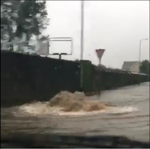
Across Saturday and Sunday the authority responded to many flood related calls across the borough which the emergency ‘out of hours’ staff responded to. However, at approximately 00:30 hrs Sunday 16th February the first floodwaters entered properties on Varteg Road.
It is important to note that the floodwater continued to rise throughout a period of approximately four hours with the first property reporting flooding at 00:30 hrs and the last at 04:00 hrs. It is also understood the floodwaters did not recede until around midday Sunday, the following day.
A total number of 29 properties suffered internal flooding on 16th February in Ystalyfera, including 27 on Varteg Road, 1 on Ffordd Emlyn and 1 outbuilding on Ynysydarren Road.
Figure 5 below illustrates those properties.
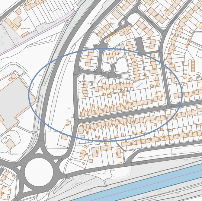
The residential area of Varteg Estate and the immediate surrounding area forms part of the river Tawe flood plain in Ystalyfera. The Varteg catchment measures approximately 400m at its widest point and covers an area of circa 10 hectares.
The topography of the area is relatively flat, varying in level between 62.9m and 56.6m above ordnance datum the latter being at its lowest point that is situated around the Varteg Road and Ynysydarren junction. The river Tawe borders the site to the South East with a steep sided hillside and A4067 embankment to the North West. The underlying superficial geology consists of alluvial silts, sands and clays deposited over time by the river Tawe however, little of these soils are exposed due to the hardstanding development that is Varteg Estate.
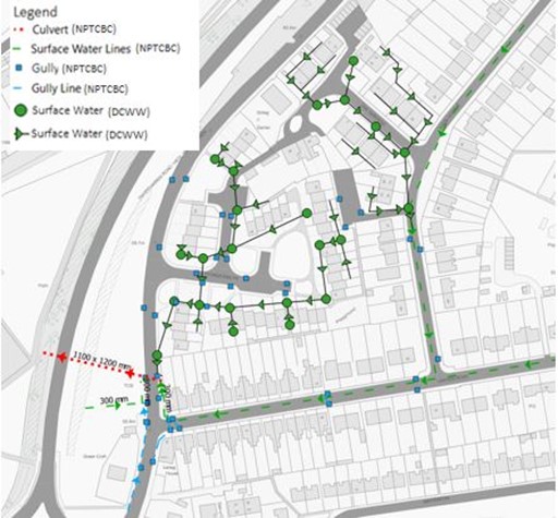
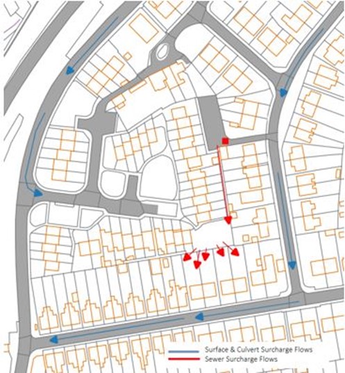
Figure 6 identifies surface water, land drainage and DCWW networks in the vicinity of the flooding incident, as identified in the legend.
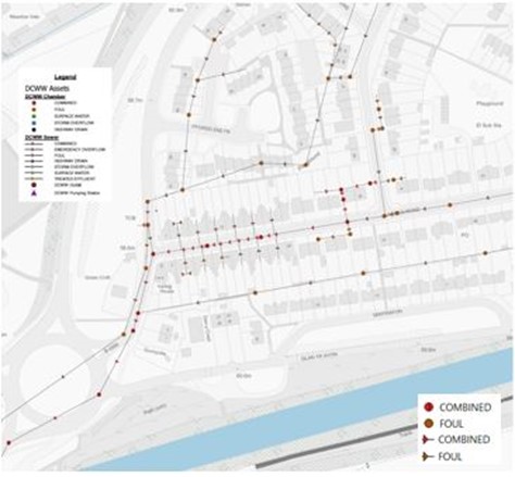
There is also a widespread DCWW combined sewer network which is fed into a trunk sewer that bisects the catchment, running through the Varteg Estate and Ynysydarren Road junction before continuing down the Swansea valley, shown in Figure 7.
Varteg Estate
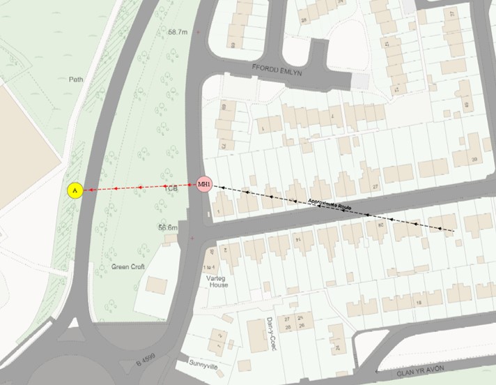
Figure 8 below illustrates the surface water flow paths in the area discharging into the 1.2m diameter culvert (MH1 shown in Figure 10), which runs in a Westerly direction under the A4067.
Ynysydarren
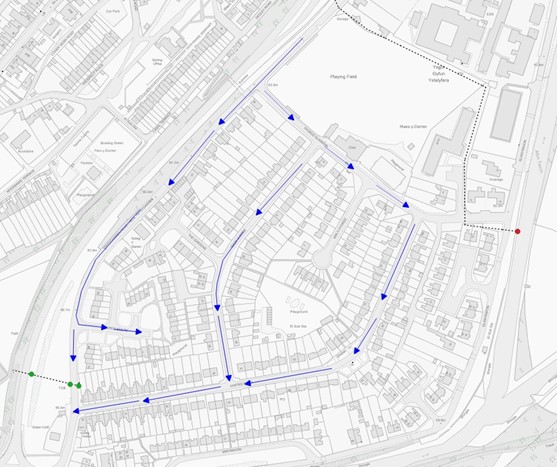
A culverted watercourse crosses under Ynysydarren Road near to the northern most corner of Ystalyfera rugby fields. The culvert runs under what was private land (which has since been purchased by the council), along the northern boundary of the fields before entering a chamber in the grounds of numbers 1 – 35 Maes Y Darren, which is managed by Tai Tarian. From this point the culvert turns 90o before discharging into the Afon Twrch. The culverted watercourse does not interact with the drainage system serving the Varteg Estate during normal flows. However if the culvert surcharges from the Ynysydarren Road inspection chamber (shown in figure 11), as it did during the 2016 and 2020 flood event the water is channelled through the Varteg Estate to the low point (MH1 – Figure 10) of the catchment via the flow path seen below in Figure 9.
During the flood event, surcharged water from the contributing sources and surface water run off all flowed to the low point in the area at the Ynysydarren and Varteg Road junction.
Chamber MH1 (figure 10) is situated at the lowest point and is the point at which all surface water drainage networks discharge to. MH1 is built on a 1.2 metre diameter culvert that flows downstream east to west under the Varteg Estate, that would have originally supplied water to the old iron/tin works now conveys water from the estate under the A4067 towards the recently developed ASDA site. The section under the Varteg Estate itself is believed to be redundant other than it provides some storage capacity for flows entering MH1. Further to the investigation it is believed that water was then historically conveyed via a culvert system down the valley, before out falling downstream on the banks of the river Tawe.
Ynysydarren
Previously it was investigated that the section of the culvert downstream of Ynysydarren Road highlighted reduced capacity, caused by a partial collapse of the culvert on privately owned land.
Since these inspections, the Council acting as LLFA, decided to purchase the 3rd party land in order to undertake vital repair works to the culvert in order to prevent flooding to the community.
The existing culvert has since been removed and replaced with a new larger 900mm diameter pipe. This scheme has already proved successful and reduced the flood risk to the residents of the Varteg Estate.
Varteg Estate
During the latter hours of Saturday the 15th February, the design capacity of the surface water drainage system in Varteg Estate was exceeded, causing overland flows to the junction of Ynysydarren and Varteg Road. As previously stated, it was the additional surcharging flows from the Ynysydarren chamber that had a significant impact on the drainage capacity. At approximately 00:30hrs Sunday 16th February along Varteg Road started to flood.
Under the WG small scale-funding scheme, NPTCBC commissioned an independent subcontractor to install flood defence doors to 12no properties residing in Varteg Road. Officers in immediate attendance following the flood event recorded ingress of water through the doors was present.
Inspections were also made to the temporary pumping station near to MH1, which were deemed to be working at the time of the event. It was the additional surcharged water from Ynysydarren, alongside consistent volume of water that fell during a short period of time that exceeded the capabilities of the temporary pumping station.
DCWW Network
During the early hours of Sunday 16th February, the DCWW sewer network surcharged resulting in combined sewerage flowing through Varteg Estate and contributing to the flooding. (See figures 7 & 9).
After investigations it was found the additional flows of surface water from the Ynysydarren culvert that entered the sewerage network were the cause of surcharging sewer network. During DCWW investigations, no issues to the structural integrity of the sewer network were identified.
Carrier drain from Chamber MH1 to Point A (refer figure 10)
The authority has appointed a consultant to produce an outline business case (OBC) and outline detailed design to re-establish the connection between point A and B. Since the 2020 event the council have completed the OBC and are due to complete the detailed design in April 2021. The proposed scheme is intended to once again allow surface water to flow unaided away from the Varteg housing estate and minimise the current flood risk to the local community. The report and design has been commissioned through the Welsh Governments Flood and Coastal Erosion Risk Management Programme and it’s the Authority’s intention to further the project to construction phase during financial year 21-22.
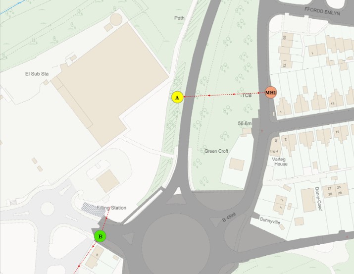
As per previous, it is the conclusion of the Authority’s investigations that the drainage system, which believed to have previously connected point A and point B (Figure 12), has been removed. This along with the impediments and collapses to the culvert on private land adjacent to Ynysydarren Road, to be the fundamental reason for the flooding.
Believing the connection from point A and point B to have been severed, the Authority has commissioned a business case with detailed designs to establish the connection. It is the Authority’s intentions to progress the project during financial year 2021-22.
As a LLFA the council initiated proceedings to purchase land adjacent to Ynysydarren road in 2020 utilising its land drainage powers, and have since rectified the length of neglected culvert.
The temporary mitigation measures introduced by the Council since the flood included building a new chamber near to the low point of the estate and installing a pump system. The system however only pumps surface water overland into the A4067 highway drainage system, and consequently its effectiveness at dealing with flood conditions can only be considered to be limited. To reduce the significant resource issues associated with maintaining the operation of the pumps the authority has since completed the installation of a permanent power supply to replace the existing fuel powered generator.
It is noted there have been some previous reports of more limited flooding by residents at Varteg Road since the development of the ASDA site; however none met the criteria for a Flood Investigation to be undertaken.